By Virginia Pritchard
Virginia started working at the Sierra Institute in the Fall of 2020 as a Collaborative Forestry Management Apprentice and will be working on West Lassen Headwaters Infrastructure Assessment and Watershed Improvement Project. She graduated from Oregon State University in 2016 with a dual B.S. in Environmental Science and Microbiology with a Chemistry minor. She began working with aquatic ecosystems in 2017 and has a background in hydrologic monitoring and research with the Forest Service. She also volunteered for Salmon Watch conducting outdoor education programs on salmon ecology for K-12 students across Oregon. In her free time, Virginia, enjoys backpacking, biking, reading, writing and being creative in general.
Before I began working with forest ecosystems, a forest road was just a road. An unimpressive means to an end. Whether accessing a trailhead, a campsite, or a spectacular view, my mind was on the destination, not the road I traveled to get there. The first time I actively noticed a road with observable impacts on the landscape was by accident. While conducting field surveys classifying water bodies in preparation for timber sale I found an unmapped tributary to a stream. I walked up the tributary, following a trail of skunk cabbages across squishy saturated soil which lead to an oval of dense, huge skunk cabbage plants. While walking around the area to map its shape and location, I came across an old abandoned forest road; a raised prism of flat native surface lining the side of the skunk cabbage patch. I looked across the road, and through the trees saw an opening. The ground was inundated with a shallow pond. Aquatic plants floating on the surface gave it a bright green and speckled appearance. Old logs were strewn crisscross throughout the water, either partially or completely submerged, and the whole pond was surrounded by dense willows and cedars. It was beautiful, healthy wetland habitat. But it would not have been there without the road.

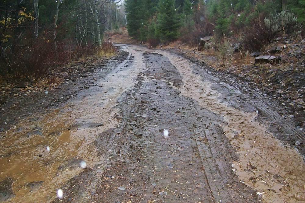
Roads have been a part of the forested landscape for as long as humans have been utilizing forest resources. Early loggers used rough cut trails to harvest timber and led oxen teams dragging logs to nearby streams where they utilized seasonal or artificial high flows to transport them to sawmills for processing.2 The majority of the existing Forest Service road system has been built since the 1930s by the Civilian Conservation Corps to create jobs, during the post-war timber harvest boom, and due to technological advances in both logging and road construction.1 As of 2019, there were about 370,000 miles of roads on Forest Service land, which does not account for the miles of forest roads on private land.1 This road mileage is significant because their construction alters the way water flows through the forest, which can result in negative impacts on water and other natural resources.
The objective of building roads in the forest was mainly to access timberlands for harvest or to aid in fire suppression without anticipating the impact roads would have on cultural, soil, wildlife and aquatic resources.1 Roads are compact impervious structures, and if they weren’t heavy equipment and passenger vehicles would not be able to utilize them.3 But their compacted nature inhibits precipitation infiltration into the soil, often creating surface flow carrying sediment along the road path. If road networks are not designed with this interaction in mind, they may deposit sediment into adjacent stream, wetland, or lake habitats.4 Impacts extend beyond altering aquatic ecosystems. This excess sediment input can threaten the longevity and functionality of downstream infrastructure and reduces the effectiveness of drinking water treatment.3,4,5,6
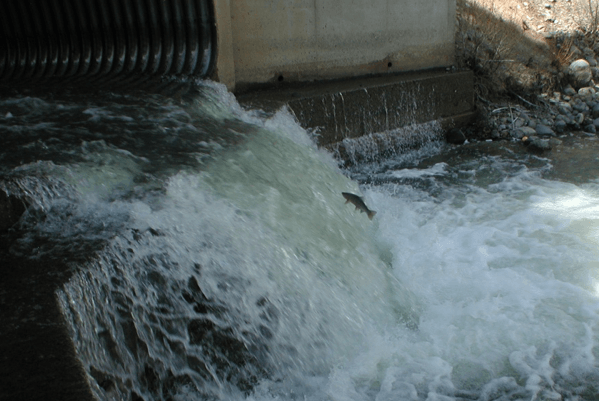
When water runs off roads into nearby streams or lakes, high concentrations of suspended sediment impact aquatic life on every trophic level. It reduces light penetration into the water column which inhibits the growth of phytoplankton and aquatic plants. Fewer phytoplankton and aquatic plants means reduced levels of dissolved oxygen for fish and macroinvertebrates to breathe.6 Additionally, sediment can transport nutrients and heavy metals which impact community water supplies and can lead to explosions in algal populations or algal blooms.5,6 Suspended sediment can reduce populations of macroinvertebrates by dislodging them from their habitat and transporting them further downstream, or kill them by clogging their guts and gills. Fish can also be affected when high concentrations of suspended sediment damage their gills, or sediment settles out of suspension into the pores of gravel beds where fish lay their eggs. This sediment blocks the eggs from accessing dissolved oxygen, suffocating them before they hatch, and in some cases suspended sediment has inhibited the success rate of egg fertilization by spawning salmon.6 All of these impacts to phytoplankton, macroinvertebrates, and fish compound on each other. Fewer phytoplankton means less food for macroinvertebrates. Fewer macroinvertebrates means less food for fish. These cascading impacts move further up the food chain affecting animals outside the aquatic system who rely on abundant fish populations such as bears, birds, and people.
The impacts of road sedimentation on water quality and fish populations did not go unnoticed in the years after miles of roads were built on National Forests. In response, Best Management Practices were developed by the U.S. Forest Service to help mitigate these and other impacts of forest management practices on natural resources. For forest roads, it is recommended they be placed or relocated as far from waterbodies as possible to avoid sensitive habitats such as riparian areas, wetlands and meadows.7 These habitats fulfill vital roles in sediment control and water retention. The vegetation and duff layers slow water down, allowing sediment to settle out and for water to soak into the ground. The water replenishes groundwater, makes nutrients available for plant uptake, and keeps excess sediment from streams. The root structures of willows and other water-loving plants common in healthy riparian areas provide bank stabilization holding soil in place. Trees adjacent to a stream may fall into the waterway, becoming food and in-stream habitat.8 Fallen tree recruitment is an especially important process for streams because they form log jams which retain sediment and create pools preferred by juvenile fish as they develop.9
Changing the way we approach constructing roads is one thing, but what do we do about established roads that deliver sediment to waterways? One way the Forest Service is addressing it is through an agency-wide effort to reduce the road network to one that is sustainable and fiscally feasible to maintain.1 After launching this initiative in January 2001 around 10,000 miles of road have been decommissioned and restored to a more natural landscape, but the process is slow and is far from the original goal of 25-40% reduction of 186,000 miles.10 In order to further safeguard aquatic ecosystems we need to increase the pace and scale at which we assess forest roads and their impacts. That is where the Watershed Infrastructure Assessment comes into play. With funding from the National Fish and Wildlife Foundation, Sierra Institute is partnering with the Lassen National Forest, Butte County RCD, and other partners in the South Lassen Watersheds Group to conduct an assessment of roads within salmon-bearing watersheds in the southwest region of the Lassen National Forest. These surveys will help us understand the amount of sediment delivered to streams and how it is delivered so these impacts can be mitigated by stream crossing upgrades and other restoration techniques. This work builds off of previous Sierra Institute work of conducting a whirling disease risk assessment throughout the Feather River Basin, and assessing fish passage issues and barriers. These projects are a continued effort to ensure our streams are safe for salmon to live and thrive.
1. Lago, Lenise. “Reducing our deferred maintenance backlog”. U.S. Forest Service, 21 June 2019, https://www.fs.usda.gov/inside-fs/leadership/reducing-our-deferred-maintenance-backlog. Accessed 3 Feb. 2021. Press Release
2. Sedell, J. R., Leone, F. N., & Duval, W. S. (1991). “Water transportation and storage of logs. American Fisheries Society Special Publication, 19, 325-368. https://andrewsforest.oregonstate.edu/sites/default/files/lter/pubs/pdf/pub3177.pdf
3. Luce, C.H., “Hydrological processes and pathways affected by forest roads: what do we still need to learn?” Hydrol. Process. 16, 2901–2904 (2002) Published online in Wiley InterScience (www.interscience.wiley.com). DOI: 10.1002/hyp.5061
4. Kristopher R. Brown, W. Michael Aust, Kevin J. McGuire, Sediment delivery from bare and graveled forest road stream crossing approaches in the Virginia Piedmont, Forest Ecology and Management, Volume 310, 2013, Pages 836-846 https://www-sciencedirect-com.weblib.lib.umt.edu:2443/science/article/pii/S0378112713006452#b0105
5. Aaron A. Rachels, Kevin D. Bladon, Sharon Bywater-Reyes, Jeff A. Hatten, Quantifying effects of forest harvesting on sources of suspended sediment to an Oregon Coast Range headwater stream, Forest Ecology and Management, Volume 466, 2020, 118123 https://www-sciencedirect-com.weblib.lib.umt.edu:2443/science/article/pii/S0378112720301572#b0080
6. G.S. Bilotta, R.E. Brazier, Understanding the influence of suspended solids on water quality and aquatic biota, Water Research, Volume 42, Issue 12, 2008, Pages 2849-2861 https://www.sciencedirect.com/science/article/pii/S0043135408001401
7. United States Department of Agriculture, Forest Service. National Best Management Practices for Water Quality Management on National Forest System Lands. https://www.fs.fed.us/biology/resources/pubs/watershed/FS_National_Core_BMPs_April2012.pdf
8. Ochterski, James. “Best Management Practices During a Timber Harvest” Finger Lakes Forests. Forest Land and Timber Harvesting. Best Management Practices: Best Management Practices During a Timber Harvest. Cornell Cooperative Extension, 2004. http://www2.dnr.cornell.edu/ext/bmp/contents/during/dur_streamside.htm
9. Beechie, T.J., Sibley, T.H., “Relationships between Channel Characteristics, Woody Debris,and Fish Habitat in Northwestern Washington Streams”, Transactions of the American Fisheries Society, vol. 126, 1997, pp. 217-229.
10. Wildlands CPR, “How Many Miles of Forest Service Roads Can We Afford?” Rightsizing the Forest Service Road System, https://wildlandcpr.org/files/rightsizing%20fact%20sheet_0.pdf